Mandurah, Western Australia
| Mandurah Western Australia |
|
 Mandurah
|
|
| Population: | 83,032 (2009) [1] (22nd) |
| • Density: | 636.1/km² (1,647.5/sq mi) |
| Postcode: | 6210 |
| Area: | 106.6 km² (41.2 sq mi) |
| Time zone: | AWST (UTC+8) |
| Location: | |
| LGA: |
|
| State District: | Mandurah, Murray-Wellington, Dawesville |
| Federal Division: | Brand, Canning |
Mandurah (pronounced /ˈmændʒʉrɑː/, /ˈmændʒrə/ or /ˈmændurə/) is the second-largest city in Western Australia and is located approximately 72 kilometres (45 mi) south of the largest city, the State Capital Perth.
Mandurah has grown from isolated holiday communities along the shores of the Peel-Harvey Estuary to a major regional city in just over a decade, in recent times forming a conurbation with nearby Rockingham and the capital Perth along the coast.
Mandurah has become a popular lifestyle alternative for Perth retirees and its connection with the Perth CBD has been strengthened with the opening of the Perth-Mandurah railway line in December 2007 and a direct road connection to the Kwinana Freeway built by late 2010. A housing affordability survey of 227 cities in 2008 ranked it the least affordable city in Australia.[2]
The city attracts a large number of tourists, including many international visitors. The city centre foreshore is home to a variety of wildlife including dolphins, pelicans, shags, and an abundance of marine life including the blue manna crab which has become synonymous with the area.
Mandurah is known for its protected waterways, beaches and excellent boating and fishing activities. The City of Mandurah holds a nationally significant arts festival in April each year, called the 'Stretch' festival which attracts wide community participation.
The population of Mandurah is around 85,000 people (2009–2010).
Contents |
Geography
The waters of the Peel Inlet and Harvey Estuary (one of Australia's larger inlet systems) form the centre of Mandurah. The estuary is approximately twice the size of Sydney Harbour. The city lies in and around this freshwater system which in turn feeds into the Indian Ocean. The city and its suburbs have many kilometres of ocean coastline most of which is sandy beaches. Mandurah also has a number of suburbs built around artificially created canal systems that extend from the Peel Inlet.
The area is governed by the City of Mandurah, although a couple of suburbs east of the Serpentine River are governed by the Shire of Murray.
Climate
Sharing a similar climate to Perth, Mandurah has a typical Mediterranean climate (Köppen classification Csb) with warm summers and cool winters. During summer (December to February), the average maximum temperature is 27°C (80°F) with an average minimum temperature of 19°C (66°F). At its extreme it can get very hot, often having a couple of days exceed 40°C (104°F) in the later half of summer. In winter (June to August), the average maximum temperature is 15°C (59°F) with an average minimum temperature of 9°C (48°F). Mandurah's proximity to the ocean moderates diurnal temperatures somewhat, with temperatures a few kilometres inland often 4 or 5 degrees warmer during summer days( or cooler during winter nights). Mandurah also receives a moderate though highly seasonal rainfall of about 850mm a year, however recent trends have seen this once reliable rainfall decrease to about 700mm a year which is still good enough for the numerous dairying farms and dams further inland. However, most of the winter rains are usually accompanied by severe winds and storms capable of causing widespread damage. These conditions are perfect for tornado formation, which Mandurah's climate is remarkable for producing one of the highest densities of tornadoes in the world [1]. Mandurah was significantly affected by a severe thunderstorm on the 21 & 22 March 2010, where 15.8mm fell and the city withstood sustained winds of 70 km/h (unlike Perth, the city received no hail). Power was cut to over a 1000 homes due to pole top fires.
| Climate data for Mandurah, Western Australia | |||||||||||||
|---|---|---|---|---|---|---|---|---|---|---|---|---|---|
| Month | Jan | Feb | Mar | Apr | May | Jun | Jul | Aug | Sep | Oct | Nov | Dec | Year |
| Record high °C (°F) | 41.0 (105.8) |
39.5 (103.1) |
37.8 (100) |
32.9 (91.2) |
28.8 (83.8) |
25.6 (78.1) |
22.2 (72) |
21.4 (70.5) |
25.6 (78.1) |
32.4 (90.3) |
37.7 (99.9) |
39.6 (103.3) |
41.0 (105.8) |
| Average high °C (°F) | 29.3 (84.7) |
29.6 (85.3) |
27.6 (81.7) |
24.4 (75.9) |
20.6 (69.1) |
18.1 (64.6) |
17.3 (63.1) |
17.7 (63.9) |
19.2 (66.6) |
21.2 (70.2) |
24.4 (75.9) |
27.0 (80.6) |
23.0 (73.4) |
| Average low °C (°F) | 17.2 (63) |
17.1 (62.8) |
15.8 (60.4) |
13.9 (57) |
11.2 (52.2) |
9.7 (49.5) |
9.0 (48.2) |
9.2 (48.6) |
9.9 (49.8) |
10.7 (51.3) |
13.6 (56.5) |
15.5 (59.9) |
12.7 (54.9) |
| Record low °C (°F) | 10.1 (50.2) |
9.7 (49.5) |
6.6 (43.9) |
5.1 (41.2) |
2.4 (36.3) |
0.9 (33.6) |
1.9 (35.4) |
0.6 (33.1) |
3.1 (37.6) |
3.8 (38.8) |
4.3 (39.7) |
9.5 (49.1) |
0.6 (33.1) |
| Precipitation mm (inches) | 9.6 (0.378) |
13.3 (0.524) |
19.6 (0.772) |
44.0 (1.732) |
126.2 (4.969) |
189.7 (7.469) |
175.4 (6.906) |
126.6 (4.984) |
84.7 (3.335) |
51.8 (2.039) |
22.8 (0.898) |
11.6 (0.457) |
875.1 (34.453) |
| Source: [3] | |||||||||||||
History
The Noongar (or Bibbulmun) people, who inhabited the South West of Western Australia, named the area Mandjar ('meeting place'). After European settlement the name changed, possibly due to mispronunciation, to Mandurah.
In December 1829, Thomas Peel arrived in Western Australia from the United Kingdom with workmen, equipment and stores on the ship Gilmore. He had financed the trip in exchange for a grant of land in the Swan River Colony. Unfortunately for him, the contract stipulated that he was to arrive by no later than 1 November 1829 and, as such, his original land grant was forfeited. Undaunted, Peel built a small settlement named Clarence south of the Swan River colony at what is known today as Woodman Point. Many problems with the settlement along with Peel's own ill-health led him to lead the remaining Clarence settlers to the area known today as Mandurah. Thomas Peel died in 1865 but Mandurah continued to grow, albeit very slowly, over the years leading to the 20th Century.
Since its founding, Mandurah was administered under the Murray Road Board until 1949, when the Mandurah Road Board was established. However, dissension within the board during the 1950s saw it suspended while Commissioner Richard Rushton oversaw the town's affairs. On 26 April 1960, the Mandurah Road Board was reconstituted, and on 1 July 1961, in accordance with the Local Government Act 1960, the Shire of Mandurah was founded.
With a mining boom in nearby Pinjarra, Jarrahdale and Wagerup and an industrial boom in Kwinana combined with an idyllic lifestyle by the coast saw Mandurah grow rapidly, and on 1 July 1987 was upgraded to the Town of Mandurah. Just three years later on 14 April 1990. Mandurah became the fifth non-metropolitan settlement in Western Australia to become a city.[4]
Economy and Employment
Much of Mandurah's economy is based on tourism, retail and manufacturing/construction. However, Mandurah is also the centre of Western Australia's third largest mining region. This includes bauxite mining and alumina refining at Pinjarra and Wagerup with the Huntly Mine at Pinjarra the largest in the world. Mandurah is also just one hour away from the Boddington Gold Mine, which has recently become Australia's largest producing gold mine.[5] It is expected that a significant portion of workers at the mine will live in Mandurah.
Transport
Highway 1 bisects the city of Mandurah as Mandurah Road towards Fremantle and Old Coast Road towards Bunbury. Meanwhile Pinjarra and Gordon/Lakes Roads serve as major east-west corridors for the northern part of the city. The Kwinana Freeway and Forrest Highway also provides a rural bypass for the city. Mandjoogoordap Drive (formerly the Mandurah Entrance Road), currently under construction and due for completion in 2010, will provide a direct link from the Kwinana Freeway to Mandurah.
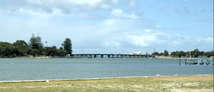
The Mandurah Estuary Bridge was constructed in 1985 to 1986, and was the first incrementally launched box girder bridge in Australia. The Dawesville Channel (also known as the Dawesville Cut), a large man-made channel, was opened in April 1994. The channel was created to allow saline seawater from the Indian Ocean to flush into the Peel Inlet to reduce the incidence of algal blooms which had plagued the estuary for many years.
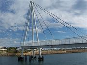
Transperth’s Mandurah railway line, opened in December 2007, links Mandurah to Perth via Cockburn Central and Rockingham.
Water use
Mandurah is at the centre of a water recycling project known as the Halls Head Indirect Water Reuse Project. Based in Mandurah it has recently been awarded the Western Australian Water Corporation Award for Water Treatment and Recycling. An aquifer is used to filter the areas sewage water providing safe, quality irrigation water for local parks, gardens and ovals [2]. Mandurah, along with Kalgoorlie is also linked to Perth's water supply.
Sport
Mandurah is home to the Peel Thunder Football Club in the West Australian Football League, Mandurah City in the Football West State League and the Pirates Rugby Union club in the RugbyWA competition. Greyhound racing is held weekly at the Greyhounds WA Mandurah venue.[6] Mandurah also hosts an SBL (State Basketball League) team called Mandurah Magic.
Golf There are mant great courses in the area including the Mandurah Country Club, Meadow Springs Golf Club, Secret Harbour. Mandurah is a great private, nice tree lined course with a friendly pro. Meadow Springs is a public great course and you will likely spot many roos. Secret Harbour is a great course right near the beach and a true public links course. There is also the Cut which is a great course along the ocean and was voted the best course in Western Australia
Mandurah is famous for its great beaches along the coast. There are many family friendly beaches such as Doddis Beach, Blue Bay and Mandurah Beach. But there are also many surf beaches sush as Avalon, 4th Groyne, Pyramids and The Wedge.
In popular culture
A photograph of Mandurah adorns the cover of the 1986 album Born Sandy Devotional by The Triffids.
References
- ↑ Australian Bureau of Statistics (25 October 2007). "Mandurah (Urban Centre/Locality)". 2006 Census QuickStats. http://www.censusdata.abs.gov.au/ABSNavigation/prenav/LocationSearch?collection=Census&period=2006&areacode=UCL516800&producttype=QuickStats&breadcrumb=PL&action=401. Retrieved 2008-02-13. Map
- ↑ Maiden, Samantha (21 January 2008). "Australian homes the world's least affordable, survey says". The Australian. http://www.news.com.au/story/0,23599,23081706-2,00.html.
- ↑ "Climate statistics for Mandurah". Australian Bureau of Meteorology. http://www.bom.gov.au/climate/averages/tables/cw_009887.shtml.
- ↑ http://www.mandurah.wa.gov.au/council/history History of Mandurah
- ↑ http://www.perthnow.com.au/business/boddington-gold-mine-to-eclipse-kalgoorlie-super-pit/comments-e6frg2qc-1225826377222
- ↑ Greyhounds WA Mandurah
External links
- City of Mandurah website
- Visitors to Mandurah website
|
||||||||
|
||||||||
|
||||||||||||||||||||||||||
|
||||||||||||||